Search engine for discovering works of Art, research articles, and books related to Art and Culture


Javascript must be enabled to continue!
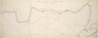
Sketch map of the Barna river from Garstin's bridge to the Old Fort, Benares
View through Europeana Collections
Pen and ink and wash sketch map of the Barna
river from Garstin's bridge to the Old Fort at Varanasi (Benares)
in Uttar Pradesh, by James Prinsep (1799-1840), dated 1824. The
image is inscribed: 'Part of the Burna Nala survey in Janry. 1824
by James Prinsep', together with the scale and main places
identified.Varanasi stands on the left bank of the Ganges and at
its highest point stood well away from the river, but as the ground
receded towards the water stagnant pools and marshes formed near
the most densely inhabited areas during the rainy season and became
a danger to health. Prinsep devised a plan to drain the city and
built a network of drains and a tunnel which were considered a
great feat of engineering. The sewer was opened in 1824 and the
tunnel, in 1827. Prinsep came from a family who served in India for
three generations; five of his brothers were also in the country.
James, also a noted scholar and antiquarian, was Assistant Assay
Master at the old Calcutta Mint in 1819, and after occupying the
position at the Benares Mint from 1820-30 finally became Assay
Master of the Calcutta Mint in 1832.
Title: Sketch map of the Barna river from Garstin's bridge to the
Old Fort, Benares
Description:
Pen and ink and wash sketch map of the Barna
river from Garstin's bridge to the Old Fort at Varanasi (Benares)
in Uttar Pradesh, by James Prinsep (1799-1840), dated 1824.
The
image is inscribed: 'Part of the Burna Nala survey in Janry.
1824
by James Prinsep', together with the scale and main places
identified.
Varanasi stands on the left bank of the Ganges and at
its highest point stood well away from the river, but as the ground
receded towards the water stagnant pools and marshes formed near
the most densely inhabited areas during the rainy season and became
a danger to health.
Prinsep devised a plan to drain the city and
built a network of drains and a tunnel which were considered a
great feat of engineering.
The sewer was opened in 1824 and the
tunnel, in 1827.
Prinsep came from a family who served in India for
three generations; five of his brothers were also in the country.
James, also a noted scholar and antiquarian, was Assistant Assay
Master at the old Calcutta Mint in 1819, and after occupying the
position at the Benares Mint from 1820-30 finally became Assay
Master of the Calcutta Mint in 1832.
Related Results
figur, skulptur, staty, statue, sculpture
figur, skulptur, staty, statue, sculpture
1887.08.5172+5173. Function: For as long as we have known, people have come to Benares to be able to meet the gods, primarily Shiva, but also to die, be cremated and be released f...
skulptur, staty, figur, sculpture, statue
skulptur, staty, figur, sculpture, statue
1887.08.5172+5173. Function: For as long as we have known, people have come to Benares to be able to meet the gods, primarily Shiva, but also to die, be cremated and be released f...
't Engelse Fort in Bombaja. 't Engelse Fort in Bombaja aande
water zyde
't Engelse Fort in Bombaja. 't Engelse Fort in Bombaja aande
water zyde
Engraving by an anonymous artist of the Fort at
Bombay in Maharashtra, dated between 1700 and 1750. The print is
captioned 't Engelse Fort in Bombaja; 't Engelse Fort in Bombaja
aa...
Sketchbook
Sketchbook
Sketchbook with black-leather-covered cardboard covers. Sewn page block; pages of off-white wove paper, each 27.2 x 20.8 cm. Drawings made in graphite and in vertical orientation...
Ten sketches for sculpture gardens
Ten sketches for sculpture gardens
One manila folder labeled "sculpture gardens" in Wilmarth's hand and ten loose sheets as follows (dates unknown):
1) Aerial (?) sketch in graphite
2) Sketch in graphite
3) Horiz...
Building work on the drainage tunnel from the Machhodri tank
to the river
Building work on the drainage tunnel from the Machhodri tank
to the river
Watercolour by James Prinsep (1799-1840), of
building work on the drainage tunnel from the Machhodri tank to the
river at Varanasi (Benares) in Uttar Pradesh, dated 1826. The image...
Step well, Benares
Step well, Benares
Pencil drawing by James Prinsep (1799-1840), of a
step well at Varanasi (Benares)in Uttar Pradesh. The image is
inscribed on the reverse: 'Section of the Ganges opposite the
Minare...
Powder bag and powder horn
Powder bag and powder horn
Engesle textThis powder bag; 1860-1870Hide, wool, glass, cow horn, wood; bag: h. 20.5 cm., w. 18 cm.\nRMV 710-7; Herman Ten Kate collection; purchased from Niagara Falls trader, 18...