Search engine for discovering works of Art, research articles, and books related to Art and Culture


Javascript must be enabled to continue!
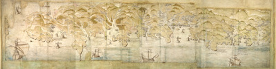
South west coast of England from Exeter to Land's End, 1539-40
View through Europeana Collections
This is a map of the south-west coast of England,
from Exeter to Land’s End. It dates from 1539-40 and its creation
can be imputed to the threat of invasion which became probable in
1538 after a peace treaty was signed by Francis I of France and
Charles V, Holy Roman Emperor and King of Spain. England and France
were ancient enemies and the Catholic Charles V, nephew of
Catherine of Aragon, was angered by Henry VIII’s decision to
divorce her. Henry’s dissolution of the monasteries provided him
with enormous wealth with which he was able to commission surveys
of the vulnerable coastline and build defence fortifications. This
map is the result of the order sent out by Thomas Cromwell in 1539
for the coasts to be surveyed by local people. These surveys, which
were often just sketches or even text, were sent to London and in
Greenwich they were edited, compiled and copied out for
presentation to the King, who displayed them in Whitehall. The
style of the map is pictorial with details such as ships, town
views and fortifications shown in accurate detail. However, it
contains vital practical information such as the state of defences
and the distance between points along the coast and measurements at
sea. Measurements at sea appear to be the estimated distance at
which the navigator could discern features of the coastline. These
are given in Dutch kennings probably due to the fact that the
draftsmen in Greenwich included Flemish artists. The purpose of the
map was to indicates, as if from the viewpoint of an invader, where
landings could be made. Therefore, the cliffs, where landings would
have been impossible are foreshortened, while the sandy beaches,
where landings would have been easy are exaggerated in size. The
sites for possible forts were then added to the map. The
annotations on this map were made in about 1541 and record the
state of fortifications, annotating ‘made’ or ‘not made’ over
several fortification and ‘half made’ over St Mawes Castle.
Although this map contains measurements for use by sailors it is
very unlikely that it would ever have been used at sea as it is
almost 10 feet long and thus highly impractical for use within the
confined space onboard ship.
Title: South west coast of England from Exeter to Land's End,
1539-40
Description:
This is a map of the south-west coast of England,
from Exeter to Land’s End.
It dates from 1539-40 and its creation
can be imputed to the threat of invasion which became probable in
1538 after a peace treaty was signed by Francis I of France and
Charles V, Holy Roman Emperor and King of Spain.
England and France
were ancient enemies and the Catholic Charles V, nephew of
Catherine of Aragon, was angered by Henry VIII’s decision to
divorce her.
Henry’s dissolution of the monasteries provided him
with enormous wealth with which he was able to commission surveys
of the vulnerable coastline and build defence fortifications.
This
map is the result of the order sent out by Thomas Cromwell in 1539
for the coasts to be surveyed by local people.
These surveys, which
were often just sketches or even text, were sent to London and in
Greenwich they were edited, compiled and copied out for
presentation to the King, who displayed them in Whitehall.
The
style of the map is pictorial with details such as ships, town
views and fortifications shown in accurate detail.
However, it
contains vital practical information such as the state of defences
and the distance between points along the coast and measurements at
sea.
Measurements at sea appear to be the estimated distance at
which the navigator could discern features of the coastline.
These
are given in Dutch kennings probably due to the fact that the
draftsmen in Greenwich included Flemish artists.
The purpose of the
map was to indicates, as if from the viewpoint of an invader, where
landings could be made.
Therefore, the cliffs, where landings would
have been impossible are foreshortened, while the sandy beaches,
where landings would have been easy are exaggerated in size.
The
sites for possible forts were then added to the map.
The
annotations on this map were made in about 1541 and record the
state of fortifications, annotating ‘made’ or ‘not made’ over
several fortification and ‘half made’ over St Mawes Castle.
Although this map contains measurements for use by sailors it is
very unlikely that it would ever have been used at sea as it is
almost 10 feet long and thus highly impractical for use within the
confined space onboard ship.
Related Results
Untitled (clockwise from top left, Christ Church Cathedral choir (from a reproduction); Tom Tower, Christ Church; Interior of hall, Christ Church; Two views of the High Street; Exterior of hall, Christ Church; Center, St. Mary's and All Souls; verso: Inte
Untitled (clockwise from top left, Christ Church Cathedral choir (from a reproduction); Tom Tower, Christ Church; Interior of hall, Christ Church; Two views of the High Street; Exterior of hall, Christ Church; Center, St. Mary's and All Souls; verso: Inte
Photograph information:
Recto; clockwise from top left
Christ Church Cathedral choir (from a reproduction)
Tom Tower, Christ Church
Interior of hall, Christ Church
T...
Deal Castle, Kent
Deal Castle, Kent
This is a plan of Deal Castle, the Tudor
artillery fort dating from around 1539. One of a chain of castles
along the south coast of England commission by Henry VIII to
protect the ...
Untitled (seven view at Oxford University, clockwise from top left, Interior of Hall, Exeter College; Library, Exeter College; Pugin's Gateway, Magdalen College; Merton Tower; Merton College; Turl Street Front; Broad Street Front; verso: clockwise from to
Untitled (seven view at Oxford University, clockwise from top left, Interior of Hall, Exeter College; Library, Exeter College; Pugin's Gateway, Magdalen College; Merton Tower; Merton College; Turl Street Front; Broad Street Front; verso: clockwise from to
Photograph information:
Recto (clockwise from top left):
Interior of Hall, Exeter College
Library, Exeter College
Pugin's Gateway, Magdalen College
Merton Tower
M...
Photographic postcard, black and white, of a girl sitting on the sand next to a black dog, taken on the south coast of England, by Remington's Photo Service (A.H. Remington), England, 1920-39. Black and white photographic postcard (landscape) of a girl si
Photographic postcard, black and white, of a girl sitting on the sand next to a black dog, taken on the south coast of England, by Remington's Photo Service (A.H. Remington), England, 1920-39. Black and white photographic postcard (landscape) of a girl si
Photographic postcard, black and white, of a girl sitting on the sand next to a black dog, taken on the south coast of England, by Remington's Photo Service (A.H. Remington), Engla...
Photograph, tinted and mounted on card, of boy wearing blue gingham waders, paddling in the sea holding a sailing boat taken on the south coast of England, by Remington's Photo Service (A.H. Remington), England, 1920s. Card mounted tinted photograph of bo
Photograph, tinted and mounted on card, of boy wearing blue gingham waders, paddling in the sea holding a sailing boat taken on the south coast of England, by Remington's Photo Service (A.H. Remington), England, 1920s. Card mounted tinted photograph of bo
Photograph, tinted and mounted on card, of boy wearing blue gingham waders, paddling in the sea holding a sailing boat taken on the south coast of England, by Remington's Photo Ser...
Photograph, tinted and mounted on card, of a boy wearing a stripy top and shorts, sitting on the sand with a spade, taken on the south coast of England, by Remington's Photo Service (A.H. Remington), England 1920-39. Card mounted tinted photograph of a bo
Photograph, tinted and mounted on card, of a boy wearing a stripy top and shorts, sitting on the sand with a spade, taken on the south coast of England, by Remington's Photo Service (A.H. Remington), England 1920-39. Card mounted tinted photograph of a bo
Photograph, tinted and mounted on card, of a boy wearing a stripy top and shorts, sitting on the sand with a spade, taken on the south coast of England, by Remington's Photo Servic...
Photograph, tinted and mounted on card, of a girl wearing a skirt, jumper and hat, posed on the beach with a set of golf clubs, taken on the south coast of England, by Remington's Photo Service (A.H. Remington), England, 1920-39. Card mounted tinted photo
Photograph, tinted and mounted on card, of a girl wearing a skirt, jumper and hat, posed on the beach with a set of golf clubs, taken on the south coast of England, by Remington's Photo Service (A.H. Remington), England, 1920-39. Card mounted tinted photo
Photograph, tinted and mounted on card, of a girl wearing a skirt, jumper and hat, posed on the beach with a set of golf clubs, taken on the south coast of England, by Remington's ...