Search engine for discovering works of Art, research articles, and books related to Art and Culture


Javascript must be enabled to continue!
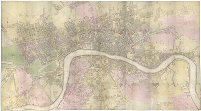
PLAN of the Cities of LONDON and WESTMINSTER the Borough of SOUTHWARK and PARTS adjoining Shewing every HOUSE. By R. Horwood.
View through Europeana Collections
This magnificent map covers 32 sheets, each
measuring 21" 5/8 x 19" 3/4. It was published sheet by sheet
between 1792 and99 and was the work of several engravers under the
direction of cartographer Richard Horwood. It is generally
considered to be the most important London map of the 18th century.
Horwood intended originally to show every house and its number but
this was to prove impossible. Although every house is included the
numbering was never completed.Horwood dedicated this map to the
Trustees and Directors of the Phoenix Fire Office, reflecting that
the protection of London from fire was at this time the reserve of
numerous independent company brigades. The map is coloured,
describing parks in green and the London Wall in red. The Tower of
London is shown only by outline; Horwood records that: 'The
Internal Parts not distinguished being refused permission to take
the Survey', evidence that a surveyor was not always
welcome.Southwark was traditionally a district where the industries
of brewing and tanning, unwelcome in the main city, were located.
Barclay Perkins & Cos., which in the coming century was to
become the largest brewery in the world, is marked on the map, as
is Guy's Hospital ("for incurables") which at had recently been
extended to include a new hospital for the psychiatrically
disturbed. This map was reissued at least four times, with relevant
additions and alterations, up until 1819.
Title: PLAN of the Cities of LONDON and WESTMINSTER the Borough of
SOUTHWARK and PARTS adjoining Shewing every HOUSE. By R.
Horwood.
Description:
This magnificent map covers 32 sheets, each
measuring 21" 5/8 x 19" 3/4.
It was published sheet by sheet
between 1792 and99 and was the work of several engravers under the
direction of cartographer Richard Horwood.
It is generally
considered to be the most important London map of the 18th century.
Horwood intended originally to show every house and its number but
this was to prove impossible.
Although every house is included the
numbering was never completed.
Horwood dedicated this map to the
Trustees and Directors of the Phoenix Fire Office, reflecting that
the protection of London from fire was at this time the reserve of
numerous independent company brigades.
The map is coloured,
describing parks in green and the London Wall in red.
The Tower of
London is shown only by outline; Horwood records that: 'The
Internal Parts not distinguished being refused permission to take
the Survey', evidence that a surveyor was not always
welcome.
Southwark was traditionally a district where the industries
of brewing and tanning, unwelcome in the main city, were located.
Barclay Perkins & Cos.
, which in the coming century was to
become the largest brewery in the world, is marked on the map, as
is Guy's Hospital ("for incurables") which at had recently been
extended to include a new hospital for the psychiatrically
disturbed.
This map was reissued at least four times, with relevant
additions and alterations, up until 1819.
Related Results
PLAN of the Cities of LONDON and WESTMINSTER the Borough of
SOUTHWARK and PARTS adjoining Shewing every HOUSE. By R.
Horwood
PLAN of the Cities of LONDON and WESTMINSTER the Borough of
SOUTHWARK and PARTS adjoining Shewing every HOUSE. By R.
Horwood
Map of London printed in 32 sheets and published
sheet by sheet between 1792 and 1799, the work of several engravers
working to the direction of the cartographer Richard Horwood.
H...
The common garden orator - or aut Caesar aut Nullus
The common garden orator - or aut Caesar aut Nullus
Pub by S W Fores 50 Piccadilly, Octr 14. 1800\no. 21 London, Nov. 11, 1800./ refers to Foxen's speech at the Whig Club which was so riotous and without ceremonies that Fox here is ...
Porträt Zachary Pearce (1690-1774)
Porträt Zachary Pearce (1690-1774)
Portrait of Zachary Pearce. The British bishop is shown here as a chest image facing to the right in the three-quarter profile. His head is slightly turned and his view front. He w...
HARRIS'S PLAN of LONDON, WESTMINSTER and the BOROUGH of
SOUTHWARK, with all the additional Streets, Squares andc; also the
improved ROADS to the Year 1791.
HARRIS'S PLAN of LONDON, WESTMINSTER and the BOROUGH of
SOUTHWARK, with all the additional Streets, Squares andc; also the
improved ROADS to the Year 1791.
This is the sixth edition of an original 1779
map. Differences between this edition and the previous one suggest
that the plate was re-engraved, at least in part, as new and
propos...
The South Façade of Warwick Castle
The South Façade of Warwick Castle
Canaletto visited England in 1746, arriving there in the spring. The celebrated Venetian artist travelled with a letter of recommendation from one of his most important protectors,...