Search engine for discovering works of Art, research articles, and books related to Art and Culture


Javascript must be enabled to continue!
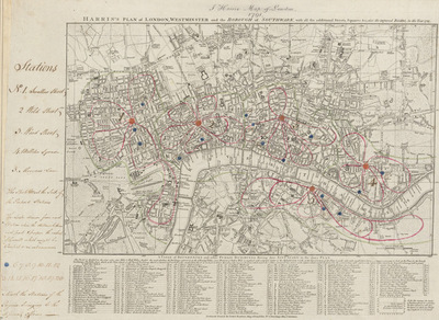
HARRIS'S PLAN of LONDON, WESTMINSTER and the BOROUGH of SOUTHWARK, with all the additional Streets, Squares andc; also the improved ROADS to the Year 1791.
View through Europeana Collections
This is the sixth edition of an original 1779
map. Differences between this edition and the previous one suggest
that the plate was re-engraved, at least in part, as new and
proposed buildings have been added. Most strikingly, 20 proposed
locations for fire stations are depicted, along with their
catchment areas. The Metropolitan Fire Brigade was not formed until
1865. A number of different company brigades had co-operated with
each other as the London Fire Engine Establishment since 1833. The
failure of this service to stop the destruction of the Houses of
Parliament in 1837 led to criticism, increasing when a fire in
Tooley Street raged for two days.
Title: HARRIS'S PLAN of LONDON, WESTMINSTER and the BOROUGH of
SOUTHWARK, with all the additional Streets, Squares andc; also the
improved ROADS to the Year 1791.
Description:
This is the sixth edition of an original 1779
map.
Differences between this edition and the previous one suggest
that the plate was re-engraved, at least in part, as new and
proposed buildings have been added.
Most strikingly, 20 proposed
locations for fire stations are depicted, along with their
catchment areas.
The Metropolitan Fire Brigade was not formed until
1865.
A number of different company brigades had co-operated with
each other as the London Fire Engine Establishment since 1833.
The
failure of this service to stop the destruction of the Houses of
Parliament in 1837 led to criticism, increasing when a fire in
Tooley Street raged for two days.
Related Results
PLAN of the Cities of LONDON and WESTMINSTER the Borough of
SOUTHWARK and PARTS adjoining Shewing every HOUSE. By R.
Horwood.
PLAN of the Cities of LONDON and WESTMINSTER the Borough of
SOUTHWARK and PARTS adjoining Shewing every HOUSE. By R.
Horwood.
This magnificent map covers 32 sheets, each
measuring 21" 5/8 x 19" 3/4. It was published sheet by sheet
between 1792 and99 and was the work of several engravers under the
directio...
Engraved gold frame enclosing a ceramic cameo on blue enamel of the Reverend John Wesley (1703-1791), England, dated 1791. Engraved gold frame enclosing a ceramic cameo on blue enamel ground of John Wesley (1703-1791) with the inscription 'He Rests From H
Engraved gold frame enclosing a ceramic cameo on blue enamel of the Reverend John Wesley (1703-1791), England, dated 1791. Engraved gold frame enclosing a ceramic cameo on blue enamel ground of John Wesley (1703-1791) with the inscription 'He Rests From H
Engraved gold frame enclosing a ceramic cameo on blue enamel of the Reverend John Wesley (1703-1791), England, dated 1791. Engraved gold frame enclosing a ceramic cameo on blue ena...
PLAN of the Cities of LONDON and WESTMINSTER the Borough of
SOUTHWARK and PARTS adjoining Shewing every HOUSE. By R.
Horwood
PLAN of the Cities of LONDON and WESTMINSTER the Borough of
SOUTHWARK and PARTS adjoining Shewing every HOUSE. By R.
Horwood
Map of London printed in 32 sheets and published
sheet by sheet between 1792 and 1799, the work of several engravers
working to the direction of the cartographer Richard Horwood.
H...
The common garden orator - or aut Caesar aut Nullus
The common garden orator - or aut Caesar aut Nullus
Pub by S W Fores 50 Piccadilly, Octr 14. 1800\no. 21 London, Nov. 11, 1800./ refers to Foxen's speech at the Whig Club which was so riotous and without ceremonies that Fox here is ...
Porträt Zachary Pearce (1690-1774)
Porträt Zachary Pearce (1690-1774)
Portrait of Zachary Pearce. The British bishop is shown here as a chest image facing to the right in the three-quarter profile. His head is slightly turned and his view front. He w...