Search engine for discovering works of Art, research articles, and books related to Art and Culture


Javascript must be enabled to continue!
World map, about 1: 50,000,000, karte, 1864
View through Europeana Collections
General map of the world in Mercator 's Projection: on the overview of the postship and recent trips around the earth/by Hermann Berghaus. -; [Approx. 1: 50,000,000], Mercator-Proj. - Gotha: Perthes; Gotha: C. Hellfarth, 1864. - 1 Kt. : multicolored. ; 76 x 58 cm. - Zero meridian: Greenwich. - With mountain strokes, postship routes, itineraries... and 5 incidental.: General wind map. Lines of identical magnetic misdirection for the year 1855. Western hemisphere. Eastern hemisphere. Landenge Eden
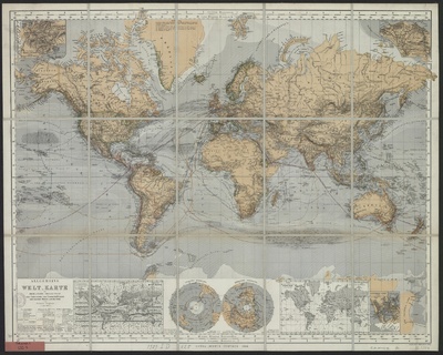
Title: World map, about 1: 50,000,000, karte, 1864
Description:
General map of the world in Mercator 's Projection: on the overview of the postship and recent trips around the earth/by Hermann Berghaus.
-; [Approx.
1: 50,000,000], Mercator-Proj.
- Gotha: Perthes; Gotha: C.
Hellfarth, 1864.
- 1 Kt.
: multicolored.
; 76 x 58 cm.
- Zero meridian: Greenwich.
- With mountain strokes, postship routes, itineraries.
and 5 incidental.
: General wind map.
Lines of identical magnetic misdirection for the year 1855.
Western hemisphere.
Eastern hemisphere.
Landenge Eden.
Related Results
Le Charivari, July 1, 1864–December 31, 1864
Le Charivari, July 1, 1864–December 31, 1864
Lithographs and wood engravings...
South west coast of England from Exeter to Land's End,
1539-40
South west coast of England from Exeter to Land's End,
1539-40
This is a map of the south-west coast of England,
from Exeter to Land’s End. It dates from 1539-40 and its creation
can be imputed to the threat of invasion which became probable i...
PLAN of the Cities of LONDON and WESTMINSTER the Borough of
SOUTHWARK and PARTS adjoining Shewing every HOUSE. By R.
Horwood.
PLAN of the Cities of LONDON and WESTMINSTER the Borough of
SOUTHWARK and PARTS adjoining Shewing every HOUSE. By R.
Horwood.
This magnificent map covers 32 sheets, each
measuring 21" 5/8 x 19" 3/4. It was published sheet by sheet
between 1792 and99 and was the work of several engravers under the
directio...
Das heutige Europa - Landkarte - Propaganda -Illustrierte Broschüre - [2 Szenarien mit Karten] - Berlin
Das heutige Europa - Landkarte - Propaganda -Illustrierte Broschüre - [2 Szenarien mit Karten] - Berlin
"Opposing the “Europe of the Future” in the Allied Brains. Today’s Europe after the war map, as they designed the allied army of the central powers. Answer and fist pledge against ...
Untitled (Owersby Vicarage (Lincolnshire) with group of five people and one horse, August 1864; verso: Owersby Vicarage with woman standing in window, August 1864)
Untitled (Owersby Vicarage (Lincolnshire) with group of five people and one horse, August 1864; verso: Owersby Vicarage with woman standing in window, August 1864)
Henry Robert Lloyd was the vicar at Owersby (reference to Cadwgan Grey Lloyd's death in the November Gentlemen's Magazine, 1858)....
Karte von Mittelfranken und von der Markgrafschaft Ansbach, 1:140 000, Kupferstich, um 1720
Karte von Mittelfranken und von der Markgrafschaft Ansbach, 1:140 000, Kupferstich, um 1720
Vetter, Johann Georg: Tabula Geographica Nova Exhiben Partem Infra Montanam Burggraviatus Norimbergensis Sive Principatum Onolsbacensem Cum Terris Limitaneis Accurate Delineatam: S...
Karte von dem Herzogtum Pommern, 1:780 000, Kupferstich, um 1700
Karte von dem Herzogtum Pommern, 1:780 000, Kupferstich, um 1700
[Pomeraniae Ducatus Tabula] Serenissimo, Celsissimo ac Invictissimo Principi, Frederico Guilielmo, D. G. Marchioni Brandenburgico, S. R. I. Electori et Archicamerario etc. Pomerani...