Search engine for discovering works of Art, research articles, and books related to Art and Culture


Javascript must be enabled to continue!
The City of New York: Longworth's Explanatory Map and Plan
View through The Met
Hand-colored engraving
Rights: Public Domain
Drawings and Prints, Metropolitan Museum of Art New York NY, The Edward W. C. Arnold Collection of New York Prints Maps and Pictures Bequest of Edward W. C. Arnold 1954
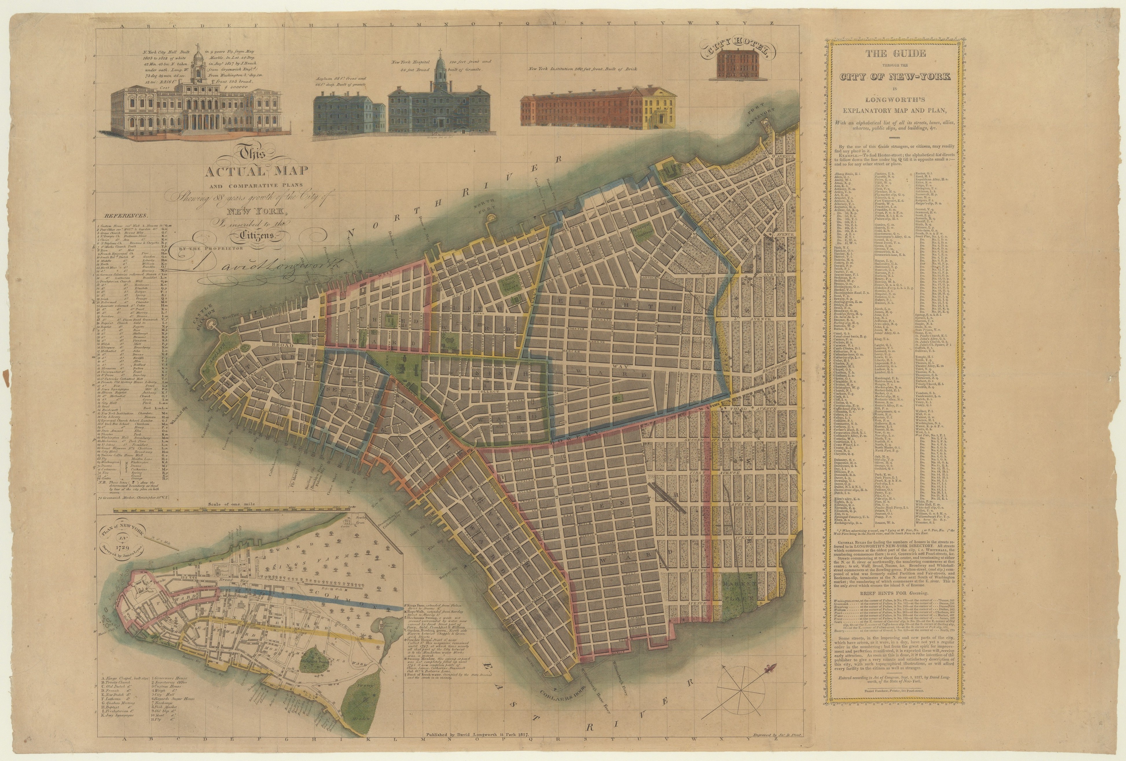
Title: The City of New York: Longworth's Explanatory Map and Plan
Description:
Hand-colored engraving.
Related Results
Das heutige Europa - Landkarte - Propaganda -Illustrierte Broschüre - [2 Szenarien mit Karten] - Berlin
Das heutige Europa - Landkarte - Propaganda -Illustrierte Broschüre - [2 Szenarien mit Karten] - Berlin
"Opposing the “Europe of the Future” in the Allied Brains. Today’s Europe after the war map, as they designed the allied army of the central powers. Answer and fist pledge against ...
PLAN of the Cities of LONDON and WESTMINSTER the Borough of
SOUTHWARK and PARTS adjoining Shewing every HOUSE. By R.
Horwood.
PLAN of the Cities of LONDON and WESTMINSTER the Borough of
SOUTHWARK and PARTS adjoining Shewing every HOUSE. By R.
Horwood.
This magnificent map covers 32 sheets, each
measuring 21" 5/8 x 19" 3/4. It was published sheet by sheet
between 1792 and99 and was the work of several engravers under the
directio...
South west coast of England from Exeter to Land's End,
1539-40
South west coast of England from Exeter to Land's End,
1539-40
This is a map of the south-west coast of England,
from Exeter to Land’s End. It dates from 1539-40 and its creation
can be imputed to the threat of invasion which became probable i...
Plan of the City of New York [The Maverick Plan]
Plan of the City of New York [The Maverick Plan]
Etching and engraving...
elefantbete, carved altar tusk, elephant tusk
elefantbete, carved altar tusk, elephant tusk
Exhibition text STADEN 1998, Benin City:
“WHERE THE KING OF GRACE PREVAILS OVER LIFE AND DEATH”
The Kingdom of Benin is located in the tropical rainforest in southern Nigeria. The...
elefantbete, carved altar tusk, elephant tusk
elefantbete, carved altar tusk, elephant tusk
Exhibition text STADEN 1998, Benin City:
“WHERE THE KING OF GRACE PREVAILS OVER LIFE AND DEATH”
The Kingdom of Benin is located in the tropical rainforest in southern Nigeria. The...
PLAN of the Cities of LONDON and WESTMINSTER the Borough of
SOUTHWARK and PARTS adjoining Shewing every HOUSE. By R.
Horwood
PLAN of the Cities of LONDON and WESTMINSTER the Borough of
SOUTHWARK and PARTS adjoining Shewing every HOUSE. By R.
Horwood
Map of London printed in 32 sheets and published
sheet by sheet between 1792 and 1799, the work of several engravers
working to the direction of the cartographer Richard Horwood.
H...
Deal Castle, Kent
Deal Castle, Kent
This is a plan of Deal Castle, the Tudor
artillery fort dating from around 1539. One of a chain of castles
along the south coast of England commission by Henry VIII to
protect the ...