Search engine for discovering works of Art, research articles, and books related to Art and Culture


Javascript must be enabled to continue!
Abraham Ortelius, Candia Map (Map of Crete) (1584)
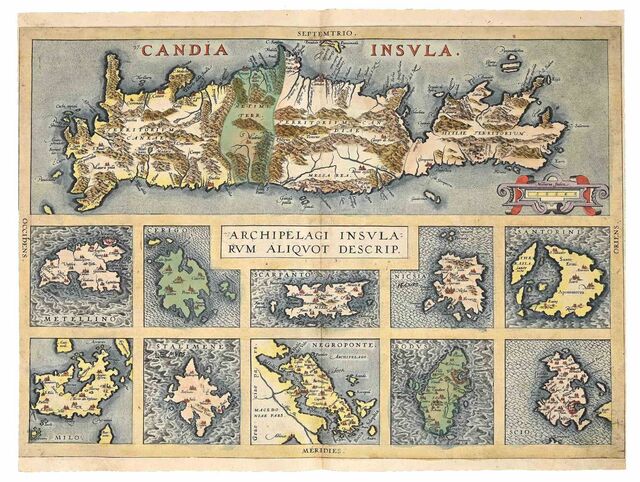
Title: Abraham Ortelius, Candia Map (Map of Crete) (1584)
Description:
Original Etching with coeval hand watercoloring.
, 36 × 49.
8 × 0.
1 cm.
Related Results
Abraham Ortelius, Culiacana and Cuba Map (Map of Culiacán and Cuba) (1584)
Abraham Ortelius, Culiacana and Cuba Map (Map of Culiacán and Cuba) (1584)
Original Etching with coeval hand watercoloring., 35.5 × 50 × 0.1 cm...
Abraham Ortelius, Cyprus Map (Map of Cyprus) (1584)
Abraham Ortelius, Cyprus Map (Map of Cyprus) (1584)
Original Etching with coeval hand watercoloring., 35 × 49.5 × 0.1 cm...
Abraham Ortelius, Cyprus Map (Map of Cyprus) (1584)
Abraham Ortelius, Cyprus Map (Map of Cyprus) (1584)
Original Etching with coeval hand watercoloring., 36 × 47 × 0.1 cm...
Abraham Ortelius, Cyprus Map (Map of Cyprus) (1584)
Abraham Ortelius, Cyprus Map (Map of Cyprus) (1584)
Original Etching with coeval hand watercoloring., 35 × 49.5 × 0.1 cm...
South west coast of England from Exeter to Land's End,
1539-40
South west coast of England from Exeter to Land's End,
1539-40
This is a map of the south-west coast of England,
from Exeter to Land’s End. It dates from 1539-40 and its creation
can be imputed to the threat of invasion which became probable i...
PLAN of the Cities of LONDON and WESTMINSTER the Borough of
SOUTHWARK and PARTS adjoining Shewing every HOUSE. By R.
Horwood.
PLAN of the Cities of LONDON and WESTMINSTER the Borough of
SOUTHWARK and PARTS adjoining Shewing every HOUSE. By R.
Horwood.
This magnificent map covers 32 sheets, each
measuring 21" 5/8 x 19" 3/4. It was published sheet by sheet
between 1792 and99 and was the work of several engravers under the
directio...