Search engine for discovering works of Art, research articles, and books related to Art and Culture


Javascript must be enabled to continue!
World map, about 1: 50,000,000, karte, 1864
View through Europeana Collections
General map of the world in Mercator 's Projection: on the overview of the postship and recent trips around the earth/by Hermann Berghaus. -; [Approx. 1: 50,000,000], Mercator-Proj. - Gotha: Perthes; Gotha: C. Hellfarth, 1864. - 1 Kt. : multicolored. ; 76 x 58 cm. - Zero meridian: Greenwich. - With mountain strokes, postship routes, itineraries... and 5 incidental.: General wind map. Lines of identical magnetic misdirection for the year 1855. Western hemisphere. Eastern hemisphere. Landenge Eden
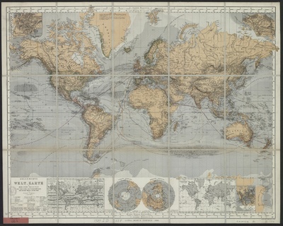
Title: World map, about 1: 50,000,000, karte, 1864
Description:
General map of the world in Mercator 's Projection: on the overview of the postship and recent trips around the earth/by Hermann Berghaus.
-; [Approx.
1: 50,000,000], Mercator-Proj.
- Gotha: Perthes; Gotha: C.
Hellfarth, 1864.
- 1 Kt.
: multicolored.
; 76 x 58 cm.
- Zero meridian: Greenwich.
- With mountain strokes, postship routes, itineraries.
and 5 incidental.
: General wind map.
Lines of identical magnetic misdirection for the year 1855.
Western hemisphere.
Eastern hemisphere.
Landenge Eden.
Related Results
portrait from "J. B. L. D.'s ... Reise nach den Senegal-Ländern in einem gedrängten Auszuge. Nebst Lamiral's Wasser- und Rubault's Landreise nach Galam. Mit 2 Kupfern und einer Karte.-G. Lajaille's Reise nach Senegal in den Jahren 1784 und 1787. Ueberse
portrait from "J. B. L. D.'s ... Reise nach den Senegal-Ländern in einem gedrängten Auszuge. Nebst Lamiral's Wasser- und Rubault's Landreise nach Galam. Mit 2 Kupfern und einer Karte.-G. Lajaille's Reise nach Senegal in den Jahren 1784 und 1787. Ueberse
This image has been taken from scan 000067 from "J. B. L. D.'s ... Reise nach den Senegal-Ländern in einem gedrängten Auszuge. Nebst Lamiral's Wasser- und Rubault's Landreise nac...
portrait from "J. B. L. D.'s ... Reise nach den Senegal-Ländern in einem gedrängten Auszuge. Nebst Lamiral's Wasser- und Rubault's Landreise nach Galam. Mit 2 Kupfern und einer Karte.-G. Lajaille's Reise nach Senegal in den Jahren 1784 und 1787. Ueberse
portrait from "J. B. L. D.'s ... Reise nach den Senegal-Ländern in einem gedrängten Auszuge. Nebst Lamiral's Wasser- und Rubault's Landreise nach Galam. Mit 2 Kupfern und einer Karte.-G. Lajaille's Reise nach Senegal in den Jahren 1784 und 1787. Ueberse
This image has been taken from scan 000099 from "J. B. L. D.'s ... Reise nach den Senegal-Ländern in einem gedrängten Auszuge. Nebst Lamiral's Wasser- und Rubault's Landreise nac...
Le Charivari, July 1, 1864–December 31, 1864
Le Charivari, July 1, 1864–December 31, 1864
Lithographs and wood engravings...
Untitled (Owersby Vicarage (Lincolnshire) with group of five people and one horse, August 1864; verso: Owersby Vicarage with woman standing in window, August 1864)
Untitled (Owersby Vicarage (Lincolnshire) with group of five people and one horse, August 1864; verso: Owersby Vicarage with woman standing in window, August 1864)
Henry Robert Lloyd was the vicar at Owersby (reference to Cadwgan Grey Lloyd's death in the November Gentlemen's Magazine, 1858)....
Three specimens of gem setting, a scarf pin with a bust of Saint George, a bust of a soldier, and a fleur de lys, gold and silver set with gem-stones, John Whenman, England (London), 1864. Three specimens of gem setting under a glass dome. The shield belo
Three specimens of gem setting, a scarf pin with a bust of Saint George, a bust of a soldier, and a fleur de lys, gold and silver set with gem-stones, John Whenman, England (London), 1864. Three specimens of gem setting under a glass dome. The shield belo
Three specimens of gem setting, a scarf pin with a bust of Saint George, a bust of a soldier, and a fleur de lys, gold and silver set with gem-stones, John Whenman, England (London...
South west coast of England from Exeter to Land's End,
1539-40
South west coast of England from Exeter to Land's End,
1539-40
This is a map of the south-west coast of England,
from Exeter to Land’s End. It dates from 1539-40 and its creation
can be imputed to the threat of invasion which became probable i...