Search engine for discovering works of Art, research articles, and books related to Art and Culture


Javascript must be enabled to continue!
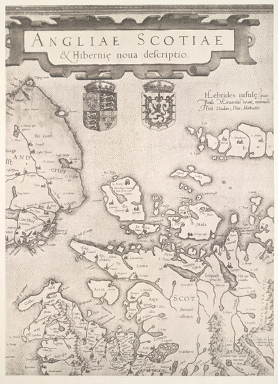
ANGLIAE, SCOTIAE & Hiberniae Nova Descriptio - Plate 3
View through Europeana Collections
This map of the British Isles is by Gerard
Mercator. It dates from 1564 and was produced in Duisburg. It was a
major new depiction of the British Isles at the time. It is a giant
map, measuring approximately 3ft by 4ft and was engraved on 8
copper plates by Mercator himself. It is drawn on a scale of 14
miles to 1 inch. Gerard Mercator was one of the greatest map makers
ever known. He started his career as a professional instrument
maker after finishing a masters degree at Louvain University and
studying advanced mathematics. By the 1560s he was developing a new
form of navigational projection. It is likely that the draft from
which Mercator developed this image of the British Isles was made
by either Laurence Nowell or John Rudd, to whom Christopher Saxton
was apprenticed. A few years before Mercator's map was published
Laurence Nowell had produced pen-and-ink drawings of the British
isles and by 1563 had compiled a manuscript atlas of 19 sheets
which was never printed. It is possible that this unpublished atlas
could have been used by Mercator as a source. The significant
developments made by Mercator's depiction is that the outline of
Wales is considerably improved with the Bay of Cardigan shown for
the very first time and Scotland is more accurately represented
than previously, so much so that it remained unchanged on
subsequent maps for the next 100 years. There are still
inaccuracies though, notably that the representation of Ireland is
incorrect, and the south coast of England is exaggerated in length
by 15%, although it features more place names than
before.
Title: ANGLIAE, SCOTIAE & Hiberniae Nova Descriptio - Plate
3
Description:
This map of the British Isles is by Gerard
Mercator.
It dates from 1564 and was produced in Duisburg.
It was a
major new depiction of the British Isles at the time.
It is a giant
map, measuring approximately 3ft by 4ft and was engraved on 8
copper plates by Mercator himself.
It is drawn on a scale of 14
miles to 1 inch.
Gerard Mercator was one of the greatest map makers
ever known.
He started his career as a professional instrument
maker after finishing a masters degree at Louvain University and
studying advanced mathematics.
By the 1560s he was developing a new
form of navigational projection.
It is likely that the draft from
which Mercator developed this image of the British Isles was made
by either Laurence Nowell or John Rudd, to whom Christopher Saxton
was apprenticed.
A few years before Mercator's map was published
Laurence Nowell had produced pen-and-ink drawings of the British
isles and by 1563 had compiled a manuscript atlas of 19 sheets
which was never printed.
It is possible that this unpublished atlas
could have been used by Mercator as a source.
The significant
developments made by Mercator's depiction is that the outline of
Wales is considerably improved with the Bay of Cardigan shown for
the very first time and Scotland is more accurately represented
than previously, so much so that it remained unchanged on
subsequent maps for the next 100 years.
There are still
inaccuracies though, notably that the representation of Ireland is
incorrect, and the south coast of England is exaggerated in length
by 15%, although it features more place names than
before.
Related Results
ANGLIAE, SCOTIAE & Hiberniae Nova Descriptio - Plate
4
ANGLIAE, SCOTIAE & Hiberniae Nova Descriptio - Plate
4
This map of the British Isles is by Gerard
Mercator. It dates from 1564 and was produced in Duisburg. It was a
major new depiction of the British Isles at the time. It is a giant
m...
ANGLIAE, SCOTIAE & Hiberniae Nova Descriptio - Plate
5
ANGLIAE, SCOTIAE & Hiberniae Nova Descriptio - Plate
5
This map of the British Isles is by Gerard
Mercator. It dates from 1564 and was produced in Duisburg. It was a
major new depiction of the British Isles at the time. It is a giant
m...
ANGLIAE, SCOTIAE & Hiberniae Nova Descriptio - Plate
6
ANGLIAE, SCOTIAE & Hiberniae Nova Descriptio - Plate
6
This map of the British Isles is by Gerard
Mercator. It dates from 1564 and was produced in Duisburg. It was a
major new depiction of the British Isles at the time. It is a giant
m...
ANGLIAE, SCOTIAE & Hiberniae Nova Descriptio - Plate
7
ANGLIAE, SCOTIAE & Hiberniae Nova Descriptio - Plate
7
This map of the British Isles is by Gerard
Mercator. It dates from 1564 and was produced in Duisburg. It was a
major new depiction of the British Isles at the time. It is a giant
m...
ANGLIAE, SCOTIAE & Hiberniae Nova Descriptio - Plate
1
ANGLIAE, SCOTIAE & Hiberniae Nova Descriptio - Plate
1
This map of the British Isles is by Gerard
Mercator. It dates from 1564 and was produced in Duisburg. It was a
major new depiction of the British Isles at the time. It is a giant
m...
ANGLIAE, SCOTIAE & Hiberniae Nova Descriptio - Plate
8
ANGLIAE, SCOTIAE & Hiberniae Nova Descriptio - Plate
8
This map of the British Isles is by Gerard
Mercator. It dates from 1564 and was produced in Duisburg. It was a
major new depiction of the British Isles at the time. It is a giant
m...
ANGLIAE, SCOTIAE & Hiberniae Nova Descriptio - Plate
2
ANGLIAE, SCOTIAE & Hiberniae Nova Descriptio - Plate
2
This map of the British Isles is by Gerard
Mercator. It dates from 1564 and was produced in Duisburg. It was a
major new depiction of the British Isles at the time. It is a giant
m...