Javascript must be enabled to continue!
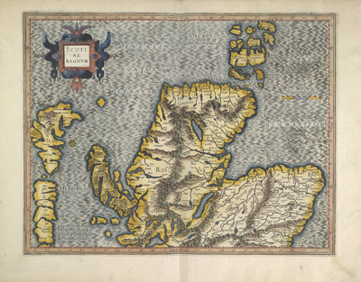
SCOTIAE REGNUM V.ii
View through Europeana Collections
This map of Scotland in two sections is by Gerard
Mercator. It dates from 1595 and was published in Duisburg by
Rumold Mercator, Gerard's son. Gerard Mercator was one of the
greatest map makers ever known. He started his career as a
professional instrument maker after finishing a masters degree at
Louvain University and studying advanced mathematics. By the 1560’s
he was developing a new form of navigational
projection.
Title: SCOTIAE REGNUM V.ii
Description:
This map of Scotland in two sections is by Gerard
Mercator.
It dates from 1595 and was published in Duisburg by
Rumold Mercator, Gerard's son.
Gerard Mercator was one of the
greatest map makers ever known.
He started his career as a
professional instrument maker after finishing a masters degree at
Louvain University and studying advanced mathematics.
By the 1560’s
he was developing a new form of navigational
projection.
Related Results
SCOTIAE REGNUM V.iii
SCOTIAE REGNUM V.iii
This map of Scotland in two section is by Gerard
Mercator.It dates from 1595 and was published in Duisburg by Rumold
Mercator, Gerard's son. Gerard Mercator was one of the greatest...
IRLANDIAE Regnum VII
IRLANDIAE Regnum VII
This map of Ireland is by Gerard Mercator. It
dates from 1595 and was published in Duisburg by Rumold Mercator,
Gerard's son. Gerard Mercator was one of the greatest map makers
eve...
IRLANDIAE REGNUM VIII.iii
IRLANDIAE REGNUM VIII.iii
This map of the southern part of Ireland forms
part of a map of the island by Gerard Mercator. It dates from 1595
and was published in Duisburg by Rumold Mercator, Gerard's son.
Ge...
ANGLIAE, SCOTIAE & Hiberniae Nova Descriptio - Plate
4
ANGLIAE, SCOTIAE & Hiberniae Nova Descriptio - Plate
4
This map of the British Isles is by Gerard
Mercator. It dates from 1564 and was produced in Duisburg. It was a
major new depiction of the British Isles at the time. It is a giant
m...
ANGLIAE, SCOTIAE & Hiberniae Nova Descriptio - Plate
5
ANGLIAE, SCOTIAE & Hiberniae Nova Descriptio - Plate
5
This map of the British Isles is by Gerard
Mercator. It dates from 1564 and was produced in Duisburg. It was a
major new depiction of the British Isles at the time. It is a giant
m...
ANGLIAE, SCOTIAE & Hiberniae Nova Descriptio - Plate
6
ANGLIAE, SCOTIAE & Hiberniae Nova Descriptio - Plate
6
This map of the British Isles is by Gerard
Mercator. It dates from 1564 and was produced in Duisburg. It was a
major new depiction of the British Isles at the time. It is a giant
m...
ANGLIAE, SCOTIAE & Hiberniae Nova Descriptio - Plate
7
ANGLIAE, SCOTIAE & Hiberniae Nova Descriptio - Plate
7
This map of the British Isles is by Gerard
Mercator. It dates from 1564 and was produced in Duisburg. It was a
major new depiction of the British Isles at the time. It is a giant
m...
ANGLIAE, SCOTIAE & Hiberniae Nova Descriptio - Plate
1
ANGLIAE, SCOTIAE & Hiberniae Nova Descriptio - Plate
1
This map of the British Isles is by Gerard
Mercator. It dates from 1564 and was produced in Duisburg. It was a
major new depiction of the British Isles at the time. It is a giant
m...


 Your session has timed out for security reasons.