Search engine for discovering works of Art, research articles, and books related to Art and Culture


Javascript must be enabled to continue!
Map of the aqueduct system and elevation, plan and detail of the aqueduct Acqua Giulia
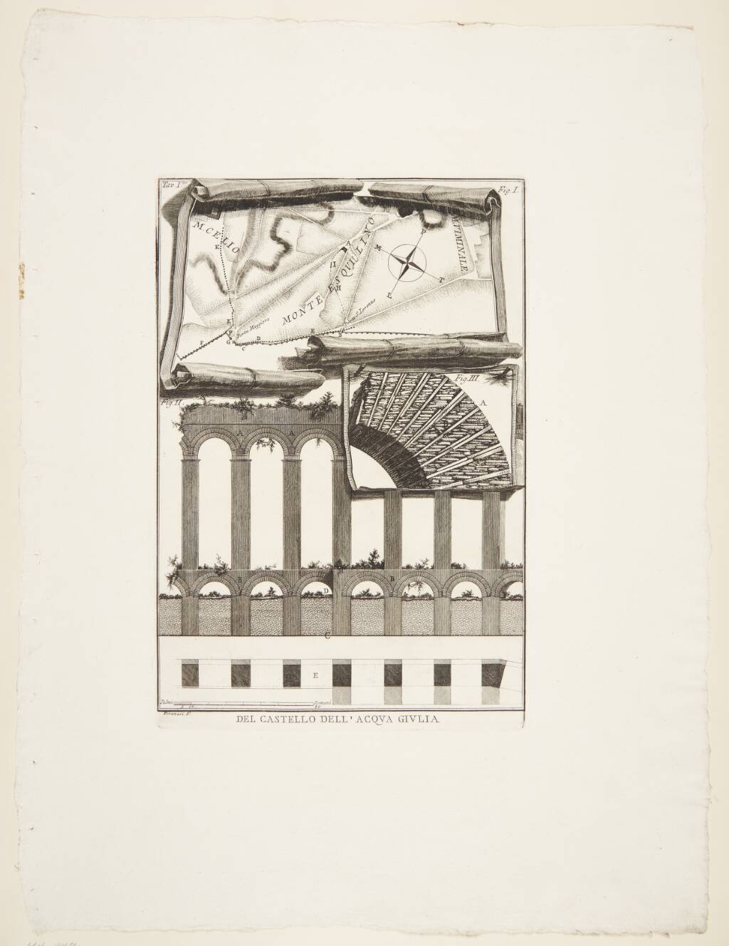
Title: Map of the aqueduct system and elevation, plan and detail of the aqueduct Acqua Giulia
Description not available.
Related Results
Concerning the Fountainhead of the Acqua Giulia [details and plan of sluices], tavola 14 from "Le Rovine del Castello dell'Acqua Giulia situato in Roma presso S. Eusebio, e falsamente detto dell'Acqua Marcia colla dichiarazione di uno de celebri passi del
Concerning the Fountainhead of the Acqua Giulia [details and plan of sluices], tavola 14 from "Le Rovine del Castello dell'Acqua Giulia situato in Roma presso S. Eusebio, e falsamente detto dell'Acqua Marcia colla dichiarazione di uno de celebri passi del
Etching, Le Rovine del Castello dell'Acqua Giulia situato in Roma presso S. Eusebio e falsamente detto dell'Acqua Marcia colla dichiarazione di uno de celebri passi del commentari...
Concerning the Fountainhead of the Acqua Giulia [section and details of Porta S. Lorenzo with ox-head motif], tavola 6 from "Le Rovine del Castello dell'Acqua Giulia situato in Roma presso S. Eusebio, e falsamente detto dell'Acqua Marcia colla dichiarazio
Concerning the Fountainhead of the Acqua Giulia [section and details of Porta S. Lorenzo with ox-head motif], tavola 6 from "Le Rovine del Castello dell'Acqua Giulia situato in Roma presso S. Eusebio, e falsamente detto dell'Acqua Marcia colla dichiarazio
Etching, Le Rovine del Castello dell'Acqua Giulia situato in Roma presso S. Eusebio e falsamente detto dell'Acqua Marcia colla dichiarazione di uno de celebri passi del commentari...
Concerning the Fountainhead of the Acqua Giulia [View of the remains of the Fountainhead or "Mostra"], tavola 2 from "Le Rovine del Castello dell'Acqua Giulia situato in Roma presso S. Eusebio, e falsamente detto dell'Acqua Marcia colla dichiarazione di u
Concerning the Fountainhead of the Acqua Giulia [View of the remains of the Fountainhead or "Mostra"], tavola 2 from "Le Rovine del Castello dell'Acqua Giulia situato in Roma presso S. Eusebio, e falsamente detto dell'Acqua Marcia colla dichiarazione di u
Etching, Le Rovine del Castello dell'Acqua Giulia situato in Roma presso S. Eusebio e falsamente detto dell'Acqua Marcia colla dichiarazione di uno de celebri passi del commentari...
Concerning the Fountainhead of the Acqua Giulia [transverse section and details of sluices], tavola 12 from "Le Rovine del Castello dell'Acqua Giulia situato in Roma presso S. Eusebio, e falsamente detto dell'Acqua Marcia colla dichiarazione di uno de cel
Concerning the Fountainhead of the Acqua Giulia [transverse section and details of sluices], tavola 12 from "Le Rovine del Castello dell'Acqua Giulia situato in Roma presso S. Eusebio, e falsamente detto dell'Acqua Marcia colla dichiarazione di uno de cel
Etching, Le Rovine del Castello dell'Acqua Giulia situato in Roma presso S. Eusebio e falsamente detto dell'Acqua Marcia colla dichiarazione di uno de celebri passi del commentari...
Concerning the Fountainhead of the Acqua Giulia [View of the remains of the Fountainhead or "Mostra"], tavola 2 from "Le Rovine del Castello dell'Acqua Giulia situato in Roma presso S. Eusebio, e falsamente detto dell'Acqua Marcia colla dichiarazione di u
Concerning the Fountainhead of the Acqua Giulia [View of the remains of the Fountainhead or "Mostra"], tavola 2 from "Le Rovine del Castello dell'Acqua Giulia situato in Roma presso S. Eusebio, e falsamente detto dell'Acqua Marcia colla dichiarazione di u
Etching, Le Rovine del Castello dell'Acqua Giulia situato in Roma presso S. Eusebio e falsamente detto dell'Acqua Marcia colla dichiarazione di uno de celebri passi del commentari...
Title page, from "Le Rovine del Castello dell'Acqua Giulia situato in Roma presso S. Eusebio, e falsamente detto dell'Acqua Marcia colla dichiarazione di uno de celebri passi del commentario Frontinano e l'esposizione della maniera con cui gli antichi Rom
Title page, from "Le Rovine del Castello dell'Acqua Giulia situato in Roma presso S. Eusebio, e falsamente detto dell'Acqua Marcia colla dichiarazione di uno de celebri passi del commentario Frontinano e l'esposizione della maniera con cui gli antichi Rom
Etching, Le Rovine del Castello dell'Acqua Giulia situato in Roma presso S. Eusebio e falsamente detto dell'Acqua Marcia colla dichiarazione di uno de celebri passi del commentari...
Ornamental letter "T" with coins of Augustus and M. Agrippa, from "Le Rovine del Castello dell'Acqua Giulia situato in Roma presso S. Eusebio, e falsamente detto dell'Acqua Marcia colla dichiarazione di uno de celebri passi del commentario Frontinano e l'
Ornamental letter "T" with coins of Augustus and M. Agrippa, from "Le Rovine del Castello dell'Acqua Giulia situato in Roma presso S. Eusebio, e falsamente detto dell'Acqua Marcia colla dichiarazione di uno de celebri passi del commentario Frontinano e l'
Etching, Le Rovine del Castello dell'Acqua Giulia situato in Roma presso S. Eusebio e falsamente detto dell'Acqua Marcia colla dichiarazione di uno de celebri passi del commentari...
Page 20 Vignette: Ornamental shield and other objects, from "Le Rovine del Castello dell'Acqua Giulia situato in Roma presso S. Eusebio, e falsamente detto dell'Acqua Marcia colla dichiarazione di uno de celebri passi del commentario Frontinano e l'esposi
Page 20 Vignette: Ornamental shield and other objects, from "Le Rovine del Castello dell'Acqua Giulia situato in Roma presso S. Eusebio, e falsamente detto dell'Acqua Marcia colla dichiarazione di uno de celebri passi del commentario Frontinano e l'esposi
Etching, Le Rovine del Castello dell'Acqua Giulia situato in Roma presso S. Eusebio e falsamente detto dell'Acqua Marcia colla dichiarazione di uno de celebri passi del commentari...